

Techniques to Generate Digital Elevation Model (DEM)
Techniques to Generate Digital Elevation Model (DEM)
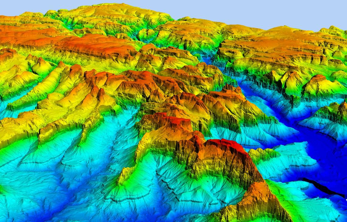
A Digital Elevation Model is a bare-earth raster grid referenced to a vertical datum. The DEM can even be obtained from stereo digital aerial imagery at various resolutions, depending on the quality and scale of the imagery.
1. Ground Survey Techniques: Ground Survey Techniques are the most widely used, in this technique we have to collect points through a ground survey. Previously this technique was used but it covers fewer areas. This is the accurate surveying of point locations. By exploring the known areas of XYZ, neighboring areas are measured using a device called a theodolite. This requires highly skilled workers, and like DGPS, all points need to be translated to produce a continuous raster.
2. Existing Topographic Maps: Topography is one of the major factors in most types of hazard analysis, and the generation of a Digital Elevation Model (DEM) plays a major role. Digital Elevation Models (DEMs) can be derived through a variety of techniques, such as digitizing contours from existing topographic maps.
3. Stereo Photogrammetry: For both aerial photography and satellite imagery, photogrammetry uses at least two images, but usually 3, different viewing angles of the same area. In this way, as in the way our vision works, we can find depth and perspective when images overlap.
4. Stereoscopic 3-D images (aerial photos, optical satellite images): Various optical satellite sensors are used for DEM generation, such as Quickbird, IKONOS (resolution 2-5 m), Pleiades 1A / 1B constellation (1m resolution), worldview-2 and GeoEye- 2 (1-2 m adjustment), Japanese Advanced Land Observing Satellite (ALOS) PRISM (2.5 m), Indian Cartosat (2.5 m), French SPOT satellite (5-10m), and ASTER ( 15-30m). Most of these have been used in risk assessment studies, on a local or small scale.
5. RADAR: DEMs are also available using radar satellites such as RADARSAT, TerraSAR-X, ALOS PALSAR, ERS-1 and 2, ENVISAT). Synthetic Aperture Radar Interferometry (InSAR) can be used to produce models Digital Elevation Models but is widely used to detect changes in high-altitude surfaces, related to various geological processes, such as landslides, slow landslides, tectonic movement, snow movement, and volcanic activity. Multi-temporal InSAR analyzes using techniques such as Permanent Scatterers (PSInSAR), PSP (Persistent Scatterers Pairs), and SBAS (Small Base-line Subset) that can be used to measure the displacement of permanent scatterers as millimetre-based accuracy.
6. Airborne Laser Scanning (LiDAR): The most detailed DEMs today are available using LiDAR. Usually, LiDAR points will provide so-called Digital Surface Models (DSM), which contain information on all objects of the earth, including buildings, trees, etc. Using algorithms, and final manually editing, the elements of the landscape are removed and generated by the Digital Terrain Model (DTM). The difference between DSM and DTM provides very useful information, eg, building height, canopy height, etc.
7. DGPS measurements: GPS or DGPS, people conduct field campaigns with special devices that use satellite information to checkpoints and determine their location. So this is a discrete method and uses an interpolated method to generate a continuous raster.
8. Digital contour lines: Use of contour maps, DTMs (DEM subset) can be easily digitized and interpolated systematically with geospatial software.
9. Spatial Interpolation: Spatial Interpolation uses known value points to estimate values ??in other points. Digital Elevation Models (DEMs) data structures are used for storing topographic information and are usually interpolated to establish the values for entire terrain points. Various software will be used directly through a point side. We can create a surface that is the DEM through interpolation or some software will also allow creating DEMs using contours. This software first converts polygon or polylines to point because these polylines are also made from point and then create spatial Interpolation. In the GIS domain, interpolation typically involves spatial points to derive a spatially continuous surface.
Major Types of Spatial Interpolation:
IDW
IDW is an exact interpolation because it is based on weightage, the weightage of each sample point is inverse proportion to the distance.
Kriging
Kriging is a geospatial method for spatial interpolation. It predicts the quality of prediction with estimated prediction errors. In this interpolation, we can find how much distance should be considered for that study location. In this method, differentiation is statistically done as compared to other interpolations. So Kriging is superior compared to other techniques. It provides a measure of the probable error associated with the estimate.
Spline
The Spline tool estimates the values ??using a mathematical function that reduces the overall curvature of the surface, resulting in a smooth surface that passes directly into the input points.
How is Satpalda Contributing to DEM?
SATPALDA provides high-resolution elevation data. It contains locations with elevations that can be used in numerous topographical applications. It may be represented as Grid data which includes raster format, interpolated values, and large storage for network analysis. some ex:
- Satellite image Orthorectification
- Military and civil aviation
- Management of oil and gas fields
- Defence and security related missions
- Watershed analysis